
Up to 1 inch of snow Friday followed by one tenth to one half inch of ice

Smokey Barn News
Friday, February 20, 2015
Robertson County,Middle Tenn.
Issued by the national weather service… Ice storm warning in effect from noon today to 9 am cst Saturday… … Winter storm warning is cancelled…
The national weather service in Nashville has issued an ice storm warning… Which is in effect from noon today to 9 am cst Saturday. The winter storm warning has been cancelled.
Timing… Noon Friday to 9 am Saturday.
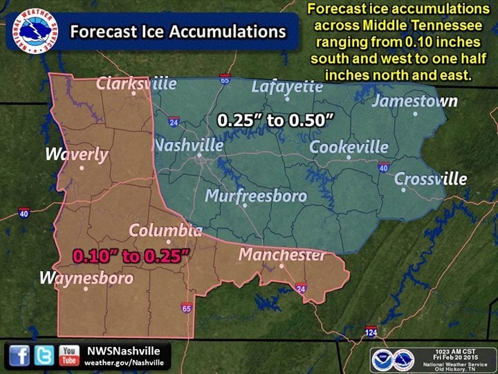
Accumulations… Up to 1 inch of snow Friday… Followed by one tenth to one half inch of ice in the form of freezing rain Friday evening through early Saturday morning. Areas along and north of interstate 40 will be the hardest hit with the best chance of approaching up to a half inch of ice.
 Ice accumulations… One quarter to one half inch across the north half of the mid state… One tenth to around one quarter of an inch across the south half.
Other impacts… Major disruptions to travel are expected Friday afternoon through early Saturday morning. Gusty winds will add to the threat for falling limbs and power outages. A coating of ice already exists on trees across much of the area and this will only worsen the threat. Warming temperatures… Melting snow and ice… And heavy rainfall will bring the potential for localized flooding on Saturday.
Precautionary/preparedness actions…
An ice storm warning means severe winter weather conditions are expected or occurring. Significant amounts of ice accumulations will make travel dangerous or impossible. Travel is strongly discouraged. Commerce will likely be severely impacted. If you must travel… Keep an extra flashlight… Food… And water in your vehicle in case of an emergency. Ice accumulations and winds will likely lead to snapped power lines and falling tree branches that add to the danger. &&
Ice and some snow expected across middle tn today and into tonight…
 A developing storm system will spread moisture into middle Tennessee today. With a deep layer of cold air initially in place… Precipitation is expected to start out as all snow. Snow will be very light this morning… Then intensity will increase this afternoon. Snowfall accumulations up to 1 inch will be possible. As we move toward late afternoon and evening hours… Warmer air will begin to push into the area… Particularly several thousand feet above ground. This will act to change the precipitation over to sleet and then quickly over to freezing rain by this evening. A developing surface trough will begin to setup to our north and thus…
The heaviest ice accumulation will be across northern areas. 1/4 to 1/2 inch of ice is expected across northern areas with up to 1/4 inch across the south. Given that a coating of ice on trees already exists across much of the area… Major problems can be expected. Warmer air will continue to move in late tonight… With wintry precipitation transitioning over to all rain beginning along the Tennessee river around midnight… And moving east to the plateau by 9 am Saturday. After the changeover to rain… Some heavy rainfall is possible through Saturday with the potential for localized flooding.
Related Stories:
Child Number Two LifeFlighted After Sledding Accident
More Dangerous Weather Coming Friday (Report & Timeline)
SPRINGFIELD ELECTRIC ASKS CUSTOMERS TO REDUCE POWER USE
Tennessee Declares State of Emergency As Road Conditions Deteriorate
Smokey Barn News (Sponsor/Advertisement)

We bring you ALL the News in and surrounding Robertson County, Tennessee.
![]()