
Power Outage Hits Parts Of Robertson County: More Likely
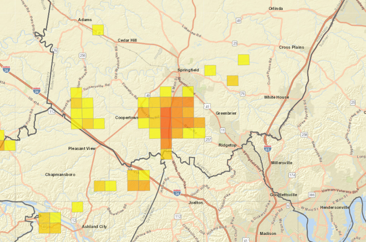
ROBERTSON COUNTY TENNESSEE: (Smokey Barn News) – About 1500 Robertson County area CEMC power customers are without power this evening due to the high winds. (See outage map below)
The Coopertown and Pleasant View area is hardest hit at the moment but more outages are likely as the winds and heavy rain persist. CEMC engineers are working as fast as they can out in the weather to restore and maintain power throughout the storm.
There are several reports of lines down and two reports of trees down, one on Ridge Rd in the Coopertown area MAP and one on Clarity Rd in Springfield. MAP
We also have reports of auto accidents coming in across the county. If you must travel expect delays and slippery road conditions.
If you have weather related issues report them and your general location below.
Smokey Barn News will continue to track the storm as it makes it’s way over Robertson County. See weather report below.
Wind Advisory Through Midnight Monday –
Wind Gusts Between 40 To 50 mph
Wind Advisory In Effect From 9 Am Monday To Midnight Cst Monday Night for most of the Middle Tennessee Area. The National Weather Service In Nashville Has Issued A Wind Advisory Which Is In Effect From 9 Am Monday To Midnight Cst Monday Night.
Timing… Monday Morning Through Monday Night.
 With Strongest Winds Expected Late Monday Afternoon Into Monday Evening. * Winds… South Winds Of 10 To 20 Mph On Monday Morning… Increasing To 15 To 30 Mph With Gusts Of 35 To 50 Mph Monday Afternoon Into Monday Evening. * Impacts… Some Trees… Tree Limbs… And Power Lines May Be Blown Down With Scattered Power Outages Possible. Loose Outdoor Objects Will Be Blown Around.
Precautionary/preparedness Actions.
A Wind Advisory Means That Winds Over 40 Mph Are Expected. Winds This Strong May Blow Down Trees Or Tree Limbs And Cause Isolated Power Outages. Secure Any Loose Outdoor Objects That Could Be Blown Around. Driving May Also Become Difficult… Especially For High Profile Vehicles. Use Extra Caution.
Strong South Winds Expected On Monday… .an Intense Storm System Will Move Across The Tennessee Valley On Monday… Bringing Increasingly Strong And Gusty South Winds To Middle Tennessee Through The Day. South Winds Of 10 To 20 Mph On Monday Morning Will Increase To 15 To 25 Mph With Gusts Up To 45 Mph By Monday Afternoon.
Winds Will Peak Monday Evening As An Area Of Low Pressure Moves Across The Region With Wind Gusts Of 40 To 50 Mph Likely Before Winds Gradually Subside Monday Night.
Smokey Barn News (Sponsor/Advertisement)

We bring you ALL the News in and surrounding Robertson County, Tennessee.