Winter weather advisory in effect from 3 am to 6 pm CST Wednesday…
ROBERTSON COUNTY TENNESSEE: (Smokey Barn News) – Wintry mix of snow and ice expected late Tuesday night and Wednesday…
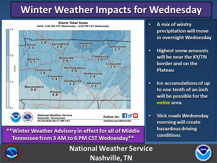
With an arctic airmass already in place a storm system will move across the region late tonight and Wednesday… Likely bringing a mix of snow… Sleet and freezing rain to the mid-state. Areas closest to the Kentucky state line and the Cumberland plateau will likely see the brunt of this system… With 1 to 3 inches of snow possible as well as one tenth of an inch of ice. The rest of middle Tennessee could see up to an inch of snow and a tenth of an inch of ice. Major travel impacts are possible so an upgrade to a winter storm warning for portions of middle Tennessee may become necessary.
Timing… 3 am until 6 pm CST Wednesday.
Main impact area… 1 to 3 inches of snow as well as up to one tenth of an inch of ice for areas along and north of i-40 (Robertson County/Kentucky Border) and the Cumberland plateau. Prepare for major travel impacts.
Nashville will likely see up to an inch of snow and a tenth of an inch of ice. Moderate travel impacts are expected.
A winter weather advisory means that periods of snow… Sleet… Or freezing rain will cause travel difficulties. Be prepared for slippery roads and limited visibilities… And use caution while driving.
NOTE: Stay Tuned to Smokey Barn News!! “IF” Robertson County Schools decide to close or delay classes due to frigid Temperatures or wintry weather conditions we will bring that information to you.
Refresh this page for updates…
Smokey Barn News (Sponsor/Advertisement) 

We bring you ALL the News in and surrounding Robertson County, Tennessee.