
ROBERTSON COUNTY TENNESSEE: (Smokey Barn News) – There are 2 waves of weather coming our way this morning. The first one is weak and becoming more weak as the day goes on. But it still can produce damaging winds and large hail. This will occur mostly in West Tennessee this morning.
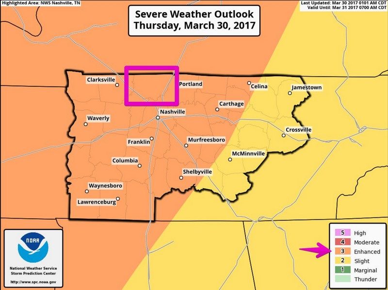
 The 2nd weather event is more severe and is the one we need to really watch. According to the National Weather Service in Nashville this storm will develop in
West Tn. in the afternoon and move into our area late today and evening. It’s threat level is considered a 4 out of a possible of 5. So this is significant for us.
We should be aware of it from about 4 p.m. til 10 p.m. tonight. What will happen? Don’t know yet, but there is a real threat of large damaging hail, strong winds and tornadoes. Do not take this as a normal storm.
Prepare for shelter for you and your animals.
This will hit at our rush hour of leaving work and traveling home. Prepare for strong
winds and hail damage to your car or house. Schools have been let out in Robertson
County due to the threat of the storm. We hope it does not do the damage it is capable of but the possibility is great. Turn on your weather radios, TVs and news. Don’t rely on only one source.
-Will Jones – Weather – Smokey Barn News


Smokey Barn News (Sponsor/Advertisement)

We bring you ALL the News in and surrounding Robertson County, Tennessee.