
Winter Storm W/Single Digits & Snow Heading Our Way
ROBERTSON COUNTY TENNESSEE: (Smokey Barn News) – Bread and milk! It’s that time of year again, temperatures are coming down and forecasters are predicting inclement weather in our future. Below is a rundown of what weather experts are predicting for both Robertson County and all of middle Tennessee in the coming week.

The National Weather Service of Nashville states, “Next weekend is going to be a cold one. That’s cold front #1. Cold front #2 is going to be painful. That one looks to come through on Monday. We *may* get a decent snow Sunday night and Monday (note the asterisks).
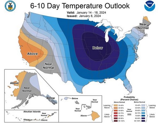
Temperatures Tuesday morning and Wednesday morning could end up in the single digits. In fact, the entire week looks to be frigid. We’re talking Siberian weather here. Note the big blue blob on the 6-10 day temperature outlook. (see graphic below) It’s big and it’s blue and it’s over us.
We are very confident in this forecast for cold temperatures. The coldest air is likely to be observed on Tuesday. Once the cold front moves through Friday night, we are likely (greater than 60% chance) to not get above 40 degrees for the afternoon high again until at least the end of next week.
The snow forecast is what we are NOT confident in as of this current time. With the cold air in place, any precipitation that does occur should be in the form of snow.
The forecast will change, and it will change again, and it will change again after that. This is what we know right now. This is just a heads up that Big Winter may be lurking in our future.”
Current Weather Outlook:
Sunday January 14, 2024 – Cloudy. Snow showers developing in the afternoon. High 34F. Winds WSW at 5 to 10 mph. Chance of snow 50%. Snow accumulations less than one inch. Snow in the evening will transition to snow showers overnight. Low near 10F. Winds NNW at 5 to 10 mph. Chance of snow 60%. 1 to 3 inches of snow expected.
Mon January 15, 2024 – Watching a potential winter storm. Occasional snow showers. High around 20F. Winds NNW at 10 to 15 mph. Chance of snow 40%. Snow accumulating 1 to 3 inches. Monday night: Scattered snow flurries and snow showers before midnight. Becoming partly cloudy later. Low -2F. Winds NNW at 5 to 10 mph. Chance of snow 30%. Snow accumulations less than one inch.
Tuesday January 16, 2024 – Sunshine and clouds mixed. High 16F. Winds WNW at 5 to 10 mph. Tuesday night – A few clouds from time to time. Low 4F. Winds light and variable.
Wednesday January 17, 2024 – Sunshine and clouds mixed. High 29F. Winds SW at 5 to 10 mph. Wednesday night – Partly cloudy. Low 19F. Winds SW at 5 to 10 mph.
Thursday 1/18 High 32 Low 12
Friday High 1/19 30 Low 11
Saturday 1/20 High 29 Low 15
Sunday 1/21 High 34 Low 22
Monday 1/23 High 39 Low 28
Tuesday January 23, 2024 – Rain and snow showers in the morning changing to mainly rain showers in the afternoon. High 42F. Winds SSE at 5 to 10 mph. Chance of rain 60%. Tuesday evening – A few showers in the evening then changing to snow showers overnight. Low near 30F. Winds light and variable. Chance of precip 60%. Snow accumulations less than one inch.
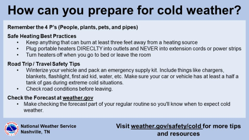
What You Can Do Now
• Prepare yourself and your home for this extended period of freezing temperatures!
• Continue to monitor the forecast for updates
Be Prepared:
Create an emergency car kit. It is best to avoid traveling, but if travel is necessary, keep the following in your car:
• Cell phone, portable charger, and extra batteries
• Items to stay warm such as extra hats, coats, mittens, and blankets
• Windshield scraper
• Shovel
• Battery-powered radio with extra batteries
• Flashlight with extra batteries
• Water and snack food
• First aid kit with any necessary medications and a pocket knife
• Tow chains or rope
• Tire chains
• Canned compressed air with sealant for emergency tire repair
• Cat litter or sand to help tires get traction, or road salt to melt ice
• Booster cables with fully charged battery or jumper cables
• Hazard or other reflectors
• Bright colored flag or help signs, emergency distress flag, and/or emergency flares
• Road maps
• Waterproof matches and a can to melt snow for water
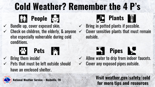
Bring your pets indoors
If you have pets, bring them indoors. If you cannot bring them inside, provide adequate shelter to keep them warm and make sure they have access to unfrozen water.
Prevent Frozen Pipes:
• Insulate Pipes. The best way to keep your pipes from freezing is to purchase specifically designed pipe insulation.
• Keep Garage Doors Closed.
• Open Cabinets.
• Let Faucets Drip.
• Keep the Thermostat Consistent.
• Seal Cracks and Openings.
• Leave the Heat On.
• Open Interior Doors.
Check On Older Neighbors
*Remember the harsh cold weather can be tough on our older neighbors, be sure to check up on them when you have an opportunity
Mobile: To See The Latest Stories or to share this article, scroll below


![]()
![]()