


Storms are expected to move into our area around 4 p.m….

Smokey Barn News Thursday Feb. 20, 2014 Robertson County, Tenn.
Special Weather Report
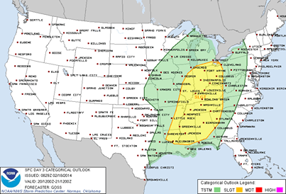
 Severe thunder storms will likely move across Middle Tennessee Thursday evening starting around 4pm and leaving the midstate around midnight. It will be warm and windy with temperatures reaching the low 70’s throughout Thursday afternoon setting the stage for possible Isolated tornadoes.
Storms are expected to move into our area around 4 p.m and are currently predicted to move out of middle Tennessee by midnight. As the storms reach their predicted peak from 6pm – 9pm this evening there will be heavy rains/lighting with the potential threat for damaging straight-line winds and gusts that could exceed 60 mph.
The National Weather Service has issued a wind advisory for Robertson County and surrounding counties until 9 p.m. Thursday. The NWS also says the strong winds will make driving difficult, especially for high-profile vehicles.
Stay tuned to this post or our Facebook page for any updates on all weather watches or warnings issued later today.
Update 4:55pm The National Weather Service has issued a tornado watch until 9 p.m. for the Western counties: Calloway, Todd, Christian, Trigg, Dickson, Hickman, Houston, Humphreys, Lewis, Montgomery, Perry, Stewart, Wayne, Henry, Decatur, Carroll, Hardin, Benton and Madison.
We bring you ALL the News in Robertson County, Tennessee.
![]()

![]()