
Weather Advisory, “Tonight/Thurs. – Storms To Bring Winds, Possible Hail, Tornadoes, Localized Heavy Rainfall”
ROBERTSON COUNTY TENNESSEE: (Smokey Barn News) – The Robertson County Emergency Management Agency is advising residents to be weather aware ahead of projected severe storms expected in our area.
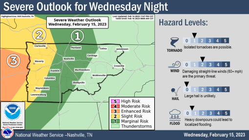
According to the Nashville – TN, US, National Weather Service, Middle Tennessee, the risk of severe storms Wednesday night and Thursday has increased with the latest SPC convective outlooks. Here are the main forecast highlights:
“We have 2 rounds of severe weather on the way with the first one coming in tonight.
Areas west of I-65 have the greatest chance of seeing severe weather tonight with the primary threats being damaging winds and isolated tornadoes. This could linger into the overnight hours, so please make sure you have a way to hear/receive warnings.
Round 2 comes tomorrow (Thursday). ALL of Middle Tennessee is at an increased risk for severe weather with the primary threats being damaging straight-line winds, localized flooding caused by heavy downpours, and isolated tornadoes. Timing for these storms will begin Thursday morning and last through Thursday evening.
The primary threats are going to be damaging straight-line winds and isolated tornadoes (1 out of 5).

There is a better chance of severe storms on Thursday along and ahead of a cold front that will sweep across the mid-state during the afternoon.
There is an increased risk of damaging straight-line winds and isolated tornadoes (2 out of 5) on Thursday. Heavy downpours could also lead to localized flooding.
Additional Information:
Impacts:
Timing: Wednesday evening/overnight & late Thursday morning into the afternoon
Areas Impacted: All of Middle Tennessee. The greatest severe weather threat Wednesday night will be west of I-65. The greatest severe weather threat on Thursday is all of Middle Tennessee west of the Cumberland Plateau.
Confidence:
Confidence is medium in the potential for storms to be able to produce significant winds and isolated tornadoes. Forecast confidence in timing is below average since the window for severe storm potential is so broad.
Forecaster Comments:
“While severe storms and supercells are certainly possible Wednesday night, the best chance remains on Thursday due to greater atmospheric instability and interaction with the cold front as it sweeps across the mid state during the afternoon.” Nashville – TN, US, National Weather Service, Middle Tennessee
What Could Change?
▪ If more widespread showers and thunderstorms persist from
Thursday around sunrise through the morning hours, it could rob
the potential for more widespread severe storms in the afternoon
▪ If there’s a more pronounced break between overnight storms
(round 1) and additional storms Thursday afternoon (round 2), it
could allow for the atmosphere to recharge and increase the
severe threat Thursday afternoon

Mobile: To See The Latest Stories or to share this article, scroll below