
Weather: High Wind Warning, Storms Expected Friday
ROBERTSON COUNTY?MIDDLE TENNESSEE: (Smokey Barn News) – The National Weather Service has issued a HIGH-WIND WARNING IN EFFECT FROM 6 AM TO 6 PM CST FRIDAY…
TONIGHT:
Rain early tonight…then remaining cloudy with thundershowers developing overnight. Low 58F. Winds ESE at 15 to 25 mph. Chance of rain 90%. Locally heavy rainfall is possible.
FRIDAY:
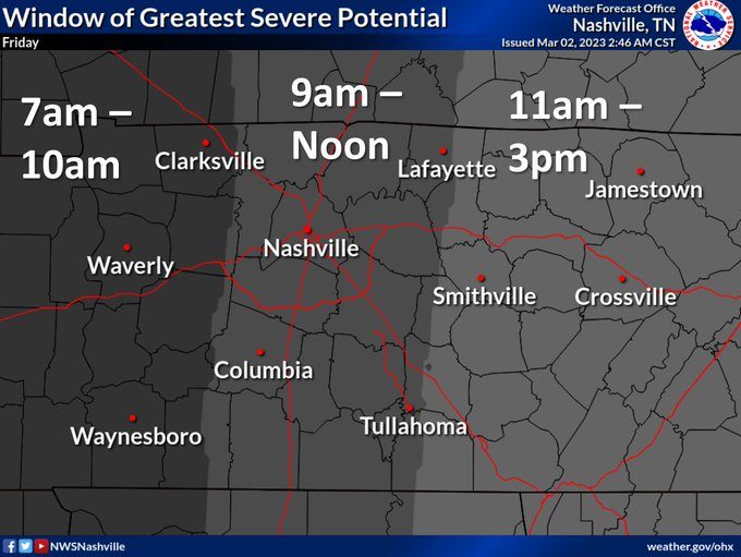
Windy with strong thunderstorms. Potential for severe thunderstorms. Morning high of 69F with temps falling to near 50. Winds SSW at 25 to 35 mph. Chance of rain 90%.
FRIDAY NIGHT: Cloudy skies early, then partly cloudy after midnight. Low 39F. WNW winds at 15 to 25 mph, decreasing to 5 to 10 mph. Winds could occasionally gust over 40 mph.

* WHAT…South winds 25 to 40 mph with gusts up to 60 mph expected.
* WHERE…All of Middle Tennessee.
* WHEN…From 6 AM to 6 PM CST Friday.
* IMPACTS…Damaging winds will blow down trees and power lines. Widespread power outages are expected. Travel will be difficult, especially for high-profile vehicles.
* ADDITIONAL DETAILS…Winds will ramp up starting around 3 am CST. With grounds already wet, some trees will come down much easier leading to power outages.
Be sure to fully charge cell phones tonight so you will be able reliably to receive any additional Severe Thunderstorm or Tornado Warnings that may be issued on Friday. Winds will begin to relax from west to east starting around sunset Friday evening.
PRECAUTIONARY/PREPAREDNESS ACTIONS…
People should avoid being outside in forested areas and around trees and branches. If possible, remain in the lower levels of your home during the windstorm, and avoid windows. Use caution if you must drive.
Mobile: To See The Latest Stories or to share this article, scroll below