

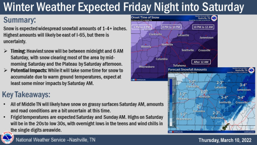
Snow, Frigid Temps Expected Friday Night Through Sunday AM
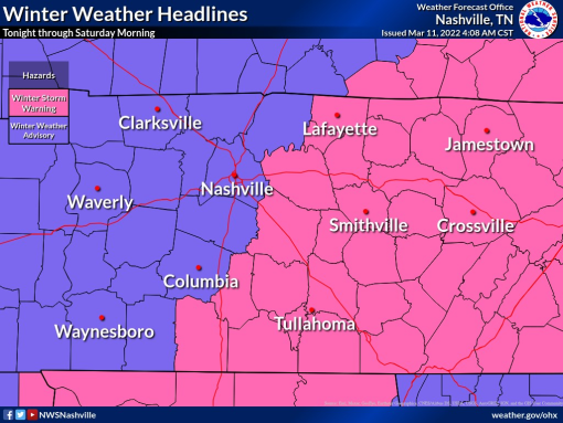
ROBERTSON COUNTY TENNESSEE: (Smokey Barn News) – “A fast-moving Winter Storm Tonight-Saturday”, according to the US National Weather Service Nashville Tennessee. Some parts of middle Tennessee are currently under a winter weather advisory while others are under a winter storm warning.
Mild today Friday, March 11, 2022…
…but a strong cold front will move through the area by this evening. Rain will change to snow this evening and continue into early Saturday morning before ending by sunrise. Frigid temps Saturday AM through Sunday AM
Snow Tonight
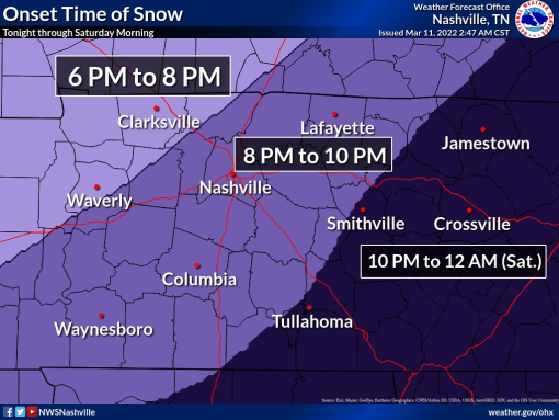
Scattered light rain will develop late this afternoon, with rain changing to snow during the evening, ending by sunrise Saturday morning. The heaviest snow will be between 9 PM Friday and 3 AM Saturday
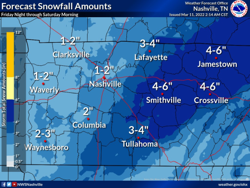
WINTER WEATHER ADVISORY along & west of I-65 for 1”-3” of snow
While it will take some time for snow to accumulate due to initially warm ground, significant travel impacts are expected to develop overnight. Roads will become snow-covered and hazardous, especially in the…
…WINTER STORM WARNING area east of I-65 for 3”-6” of snow
Sunshine will melt some snow on Saturday, but travel impacts will likely continue into Sunday morning due to frigid temperatures. Weight of snow may also knock down some trees & power lines and cause scattered power outages

Forecast confidence is high…
…that there will be snow accumulation – the biggest question is how much snow. If cold air arrives sooner and/or moisture stays around longer, snowfall amounts would increase.
If cold air arrives later and/or moisture leaves earlier,
snowfall amounts would decrease.
Because ground temperatures will be so warm at first, snow will take some time to accumulate on roads
Significant warmup Sunday through early next week
Mobile: To See The Latest Stories or to share this article, scroll below


![]()