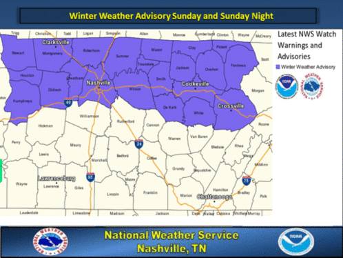
Winter Weather Advisory From Noon Sunday To 6Am Monday
MIDDLE TENNESSEE: (Smokey Barn News) – Winter weather advisory in effect from noon Sunday to 6 am cst Monday. The national weather service in Nashville has issued a winter weather advisory for a mixture of snow… Sleet… And freezing rain … Which is in effect from noon Sunday to 6 am cst Monday.
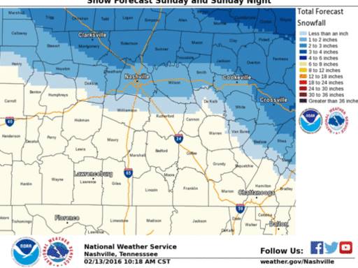
Timing: Noon Sunday until 6 am cst Monday – Snow could whiten the ground over northwestern Middle Tennessee by mid-morning, with afternoon accumulations of 1 to 3 inches possible over much of the north (generally along and north of I-40).
Areas just south of the I-40 corridor may receive accumulations between one half and one inch. Temperatures should be mild enough to keep precipitation as rain across the extreme south.
Main impact: Hazardous travel conditions across the advisory area due to a wintry mix of snow… Sleet and freezing rain.
Accumulations:One to three inches of snow and ice up to one tenth inch are possible.
A winter weather advisory means that periods of snow… Sleet… Or freezing rain will cause travel difficulties. Be prepared for slippery roads and limited visibilities… And use caution while driving.
Snow will change to rain from southwest to northeast Sunday night. Before that change occurs, there will be snow accumulations, mainly north of I-40. Sunday and Sunday night snow totals of 1 to 3 inches are expected.
Smokey Barn News (Sponsor/Advertisement)

We bring you ALL the News in and surrounding Robertson County, Tennessee.